MN COLA Newsletter here
COLA is the Minnesota Coalition of Lake Associations. The Briggs chain is a member and supporter of COLA.
Current Curly-leaf treatment plan can be found under Aquatic Invasive Page. Applied morning of May 23 2023..
Annual spring high water!
(Excuse style. New website no longer allows control of compact format. (Looks different editing than it displays- not WYSIWYG )
5/20/23 Above Curly-Leaf Plan submitted to DNR – Expect treatment to take place early next week…
5/15/23 Elk logger running. ELK & Temperature Graph added. Julia = 70 deg F. 5/12/23 Midco repaired internet connection yesterday. Elk lake sensor deployed should troubleshoot & calibrate today. 5/9/23 Unable to post due to internet issues- Request for BLCA to post was refused. Not as close to nominal as expected but should be ok by survey and treatment time. Temperature bouncing around 60 deg F. 5/5/23 Back below no-wake levels water = 52 deg F. (Julia) Optima curly-leaf treatment soon after 7/7/23…See detailed graph below…5/4/23 964.22 @ 3 AM & water = 51 degrees F. 5/3/23 3 1/4 inches above 964.1 @49 deg. F expect 5/8 to 5/9 for Ordinance to lift of “No-Wake”…4/30/23 Day 19 of what would be normally a 15 day above high water, but due to rain was turned into a 27 day projection. Yesterday effects from more rain moved projection up at least another day. As always the Palmer ordinance 3 day waiting period brings us to best case of 5/9/23 for no-wake lift… We need to see water tracking down again to know for sure…Water @ 40 deg. F. 4/29/23 Lakes continue down a little slower due to recent rain. Water temperature still 38 deg F . Levels at airport have fallen >about 7 feet and at County road 20 down near 5 feet since the the 12th. Just a 1 or 2 days away from nominal water level then 3 day ordinance wait. May 6th?4/25/23 Lake 2 feet above no-wake limit but heading down again! Water at Airport Still flowing from east (about 4 feet deep.) If a control berm were in the Bayou the level would have followed the no rain projection in graph below… Will publish Curley leaf survey when finished. Likely in 2nd week of May. 4/19/23 Projection changed after steady rain.. 2 feet above no wake 4/17/23 Water at airport down 3.7 feet since peak. Down almost 2 feet from lake peak. Updated graph below… 4/15/23 Peaked at 5am (3.12 inches more than 2022 high of 968.14), little effect from rain – yet. Updated graph below. Ice almost gone… Airport levels dropped 1 more foot since yesterday. County rd 20 bridge is down 1.4 feet since yesterday. Bayou flow slowing some. Will take about 10-15 days to get back to no-wake level (May 1st plus any rain effects) Hope to have a good start to summer near then. 4/14/23 4.0 feet above high water. The good news is the rate of rise has slowed since midnight but started moving up again around 5 am. Current rate is 0.36 inches per hour. Looks like we beat last years peak. Several roads are blocked. Simple graph loaded into current picture set below. The levels at the Airport bridge dropped about 2 feet since yesterday indicating the bubble from Benton is a little smaller but levels are up 1/2 foot since yesterday at county rd 20. This means waters will rise for at least annother day. 4/13/23 Bayou still flowing hard and about 2.5 feet above high water. Water flowing over 2 parts of 42 St. Should avoid that area between Julia boat landing and Briggs Stream on 42nd. Still not getting signal from bayou instruments. Will start trouble shooting this afternoon if I can find the time, otherwise Saturday. 4/12/23 Water from Benton County at airport has been moving fast for a few days. (still about 8 feet deep at airport today) Briggs bayou has been flowing very fast since yesterday. Unable to sink up modem yet but manual measurment from bridge indicates about 3 inches over high water. Will troubleshoot modem Thursday and hope to get real data then… 4/09/23 Area flooding is possible starting Monday and into late next week. Since December about 8 inches of water(snow) has accumulated on the ground in the Briggs Lake area. Assuming half has gone away (a crude guess) about 4 inches of water should begin flowing in the next few days. If the water moves through over the next 20 days it could cause the lakes to rise about 2 feet. The coming weather appears to show us on track for a shorter melt. (higher) The key is to watch when the Elk river jumps near the airport. Then we will have a day’s warning before the lakes follow suite. (Largest “bubble” from Benton county ditch system) This seems to be a bit more than last years peak melt of about 0.2 ft above high water melt around 3/27/22. (Or 3.94 ft 5/14/22).
High Water Alerts Signup


The Three Lake Improvement District (TLID hereafter) has contracted to treat Curly Leaf Pondweed and Eurasian Water Milfoil, Aquatic Invasive Species in Briggs, Julia and Rush Lakes in 2023.
1. Curly Leaf Pondweed treatment was completed on May 23rd, 2023
2. Eurasian Water Milfoil will be evaluated later in summer. – Hopefully there will be none found to treat…
Three Lake Improvement District
5509 108th Ave
Clear Lake, MN 55319
scott.ruiter@grede.com

Sherburne County Plans Park on Elk Lake

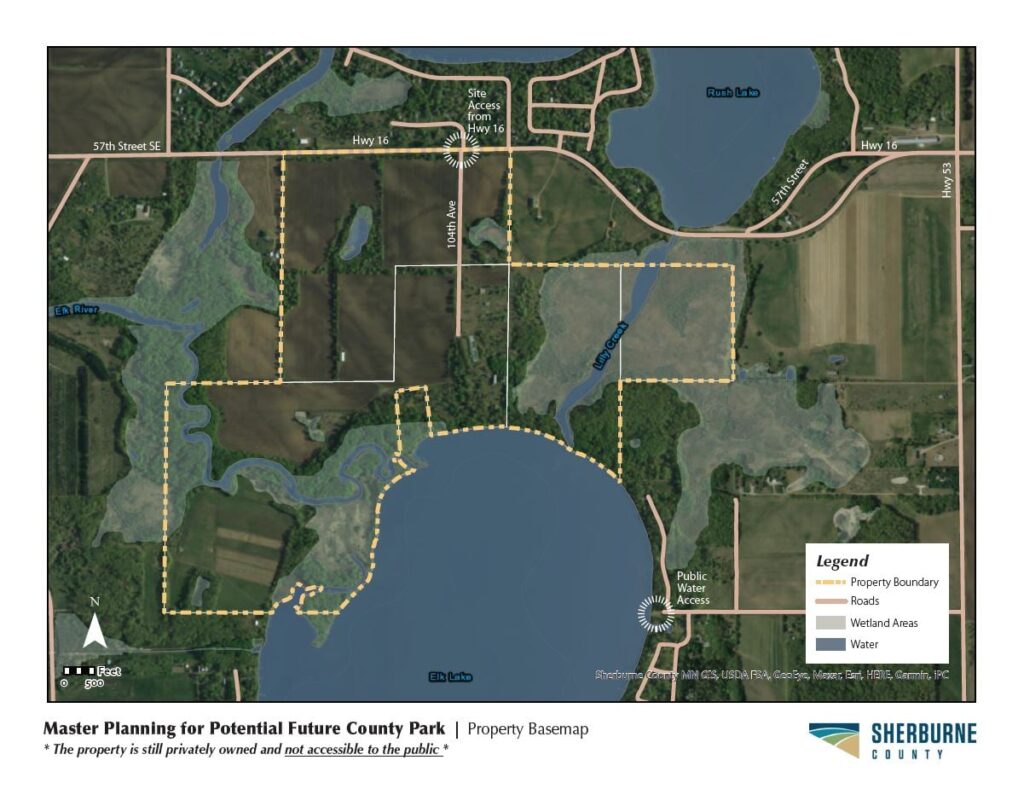
Please see article at:
https://www.sctimes.com/story/news/2021/01/29/sherburne-county-could-double-parkland-site-south-st-cloud/4220437001/